Friday, May 26, 2017

Visiting Southern Utah - Part 5

May 12 to May 16:

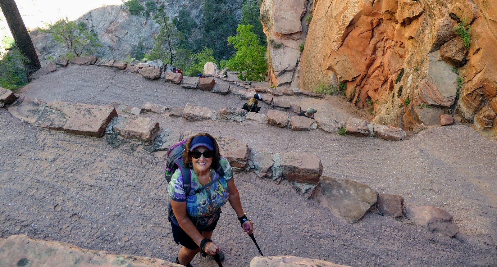
Friday we decided to do our long hike at Zion National Park. The trail is called the Angels Landing via West Rim Trail. It is a 5.4 mile round trip with an elevation change of almost 1,500 feet. We got an early start on the trail and shared the route with a number of hikers who had the same idea. We took our time going up to soak up the scenery as well as catching our breath with the elevation changes. Part of the hike was climbing several set of wiggles (switchbacks) to gain height along the trail. We reach the area near the peak of the trail where I continued on up on chains that were along the side of the mountain to reach another flat area. There was an hour wait to reach the very top (another 200 feet or so straight up) with room on the trail for only one way traffic so I decided I had gone far enough. We ate a snack and re-hydrated before we started back down. Again we took our time and watched our footing as we re-traced our steps back down the mountain. Wonderful views from the top as well as canyon walls along the trail. The entire hike took us about 4 hours including the 1/2 hour we spent on top.


Saturday and Sunday we stayed out of the national parks. On Sunday we did hike into the Red Hollow Canyon which was located a few miles south of our campground. We hiked as far into the canyon as we could until there was a rock slide that blocked the route.


Monday, May 15th, was opening day for the North Rim of the Grand Canyon. Connie and I had visited the South Rim several years ago and decided to make the 105 mile drive south from Glendale to this side of the Grand Canyon. We had to wait about 30 minutes in line to get into the park. From the entrance we traveled to the Visitor's Center and the Grand Lodge. We took a short hike out to the viewing area and also walked around the Grand Lodge. The lodge has a porch with a great view of the Grand Canyon.


View from the porch of the Grand Lodge

After leaving this area of the park we drove to the highest point in the park at Imperial Point which is 8,803 feet in elevation. From there were drove along the road to Cape Royal stopping at all of the viewing areas along the way. At each stop we took a short hike to reach the overlooks. At Cape Royal we ate our picnic lunch before hiking out the viewing areas.


The Window Bridge. We hiked to the overlook above my head.


After spending about 6 hours in the park, we made the drive north back to our campground. On Tuesday morning we got up early to make the drive to Salt Lake City.

For more photos of the North Rim of the Grand Canyon, click here.

For more photos of sites we visited outside of Bryce & Zion, click here.

For more photos of Kodachrome Basin State Park, click here. 

For more photos of Bryce Canyon National Park, click here.

For more photos of Zion National Park, click here.

Saturday, May 20, 2017

Visiting Southern Utah - Part 4

May 8 to May 11:

With the forecast of rain on Tuesday and Wednesday, we decided to do our long hike to the bottom of Bryce Canyon on Monday. We had been told that the trails that go to the bottom of Bryce Canyon stay muddy for several days after a rain, so we decided to do the hike today. We got to the entry gate at 8:00 AM and this time drove our Jeep into the park. We parked in the Sunset Point parking area which was already starting to fill up.

We decided to combine two trails to make a longer hike: The Queens Garden Trail down into the canyon and then the Navajo Loop Trail to complete the loop and make our way back to the top of the canyon. We ended up hiking about 3.5 miles with an elevation change of 600 feet.

The weather was cool at the start of the hike but we quickly warmed up once we got going on the trail. We hiked from Sunset Point to Sunrise Point and then proceeded down the Queens Garden Trail. You have a completely different perspective from the bottom of the canyon and you get close to the fins and HooDoo's.


We going to hike back up an area called Wall Street where the walls of the canyon are close together. However there had been a rock slide and only a portion of the trail was open. We hiked up to the rock slide and then retraced our steps to rejoin the main trail up to the rim.


 Once we reached the last section of the Navajo Loop Trail we had to climb a series of switchbacks (they call them wiggles) to reach the rim. We took our time and had to stop and rest several places as we climbed up.


We reached the Sunset Point parking lot, got out the lunch we had packed and ate in the picnic area. After finishing lunch we drove up to the top of the park, Rainbow Point, to hike the Bristlecone Loop. This is a 1 mile hike (at 9,000 foot elevation) that takes you out to another point at the top of Bryce Canyon.


Since there was plenty of daylight left in the day we decided to drive along Utah Hwy 12 to Grand Staircase Escalante National Monument which is a 1.9 million acre that includes a number of bluffs, high plateaus, canyons and mountains to the west of Bryce Canyon. Clint, the deputy sheriff that had opened our Jeep earlier in the week, had told us we needed to drive across the "hog's back" section of Hwy 12 so we decided to take his advice. There are wonderful scenic views all along the highway and we commented that in places it looked like we were on a different planet. The "hog's back" is a several miles of two lane road, no shoulder with drop offs of 500-700 feet on each side. This road was built during the 1930's as part of the WPA program to put men to work. Definitely would recommend that RV stay off this road (although we did see a couple during the afternoon).

Scenic overlook along Hwy 12.
Once we crossed the "hog's back'' we turned around and headed back home. Another long day where we saw some amazing sites.

Tuesday and Wednesday we had rain off and on so we stayed around the campground. We did laundry and got caught up on e-mails, Facebook and financials. On Wednesday we got good news that the Little Hollywood Museum had found Connie's prescription sunglasses. So we drove into Kanab to pick up the glasses and do some grocery shopping.

Thursday we drove up to Cedar Breaks National Monument. The road to the monument was closed but we were able to stop at an overlook near the entrance. We were at 10,500 feet in elevation and there was still quite a bit of snow on the ground.


Since the weather was nice, we drove from Cedar Breaks to the Red Canyon Visitor's Center to do a bike ride. There is a two lane paved bike trail that runs 13 miles from Red Canyon all the way to the entrance of Bryce Canyon National Park. There is quite a bit of elevation uphill on the section we biked on: we took 40 minutes going uphill and 15 minutes to make it back down. It was an early finish to our day since we made it back to the campground for a late lunch.

Friday, May 19, 2017

Visiting Southern Utah - Part 3

May 7:

Sunday we decided to hike the Mossy Cave Trail in Bryce Canyon. This trail is located away from the main portion of the park with a small parking area on Utah Hwy 12. We left early in the morning to beat the crowds and were able to get a spot in the parking lot. The trail is about a 1 mile up to the cave and then another mile back to the parking area. There were a few people on the trail but we were early enough it was not crowded. At the end of the trail is the Mossy Cave. There is also a small waterfall on a canal that was built during the 19th century to transfer water from the Sevier River to the Paria River. Mormon farmers diverted water from the East Fork of the Sevier River near Tropic Reservoir to irrigate fields around Tropic City. These early pioneers labored feverishly with primitive tools for 15 miles over three years to construct the Tropic Ditch. There are a number of HooDoo's along the trail that you view from below rather than above like we had from the rim trail.

At the base of the trail.

Mossy Cave at the end of the trail.

"Windows" in the rock formation.

More fins and HooDoo's along the trail.

Small waterfall on Tropic Ditch.

After finishing up our hike we drove over to the Kodachrome Basin State Park. The park has some interesting rock formations with different colors in the rocks. We were told that the state got permission from the Kodak company to use the Kodachrome name. We arrived at the park and paid our $8 fee for admission. From the ranger station we drove to end of the park road and got out to view the rock formations there.


Rock formation at top of the park.


Once we came back to the Jeep we realized that we had locked our keys in the vehicle. They had fallen out of Connie's pant's pocket as she was getting out of the Jeep. We tried to figure out how we were going to get into the vehicle without having to break a window. A family from Maine that were camping in the park with her parents gave us a ride back to the ranger station were we tried to get a cell phone signal unsuccessfully and their internet service was down. The rangers gave us a stiff wire clothes hanger that we tried to use but were never able to get inside the Jeep. Steve, the husband and father of the camping couple, offered to give us a ride back the nearest town which was 20 miles away. We accepted his offer and drove back towards Bryce Canyon thinking we would get a cellphone signal and call our Good Sam Roadside Assistance. We drove all the way back to the main entrance of Bryce Canyon never getting a signal. I went into the Ruby Inn located in Bryce City and found out that the fiber optic line going in that part of Utah had been cut and there was no cellphone service and no internet service. They had been told that it would be several hours before the line could be repaired. Steve drove us back towards the park and we decided to stop in Tropic to see if anyone knew of a locksmith in town (not much hope it being Sunday). We went into the local grocery store/gas station and asked them. No locksmiths in town but one of the customers in the store offered to go home and call the local Deputy Sheriff to see if he could help us. She went home and found out that the landlines were also down. Coming back to the grocery store she told us she knew the Deputy Sheriff and would drive to his house to see if he was home. Luckily he was and met us at the grocery store. While we were waiting we filled up Steve's vehicle with gas and found out that he was a physician, general internist, that worked at a small hospital in Maine. Clint, the Deputy Sheriff, followed us back out to the park and was able to use the tools in his truck to open our Jeep. Thank goodness for the kindness of strangers. We thanked Steve for his help in driving us around until we found someone who could help us. We had a nice long visit with Clint after he had opened up the Jeep. He is with the K-9 Unit of the sheriff's department and had one of his dogs with him. He actually has two dogs now although he only brought one of them with him today. One dog is in training and the other one is about to "retire". The new dog was from Texas so we had a connection. We also found out that he was the nephew of April who was the guide/driver on the Rainbow Shuttle Tour Bus we had taken a couple of days ago in Bryce Canyon National Park.

Clint with one of his tools.


Mike, Clint and Steve
 At this point we were tired and hungry. We stopped in the picnic area of the park and quickly ate our packed lunch. We took a short drive around the park, took a few pictures, stopped by to thank Steve and his family once again for all of their help and then headed home for the day.


Visiting Southern Utah - Part 2

May 5 to May 6:

Friday morning we got up early to make our second visit to Zion National Park. We were going to see the upper section of the park called the Kolob Canyons. This section of Zion is the least visited area of the park.


Before we made our visit to Kolob Canyons we drove along the Kolob Terrace Road to see more interesting rock formation along with an overlook back to the main part of Zion called Lava Point. We drove through the main section of Zion on Hwy 9 through the towns Springdale and Rockville before turning on the Kolob Terrace Road near Virgin, Utah. This is a winding road that goes through several canyons and mountains before reaching the Kolob Reservoir. We passed several scenic views along the way where we pulled over to look and take pictures. Lava Point was on a gravel road off the Terrace road that winds it way to the overlook at an elevation of 7,890 feet. We hiked about a quarter mile to the Lava Point Overlook and viewed the main section of Zion to the southeast. From there we traveled to the Kolob Reservoir where we ate the picnic lunch we had packed.

Kolob Terrace Road scenic route.

HooDoo's along the Kolob Terrace.

Small lake along route that we saw Koy Fish spawning.

More canyons along the route.

Kolob Reservoir where they were having a fly fishing class & where we ate lunch.

The only way to get to the main part of Zion from here is to hike the rim trail.

Looking at main section of Zion from Lava Point.
We drove back down the Kolob Terrace Road to Hwy 9, then proceeded on to I-15 where we turned north. We drove several miles along the interstate before exiting at the Kolob Canyons Visitor's Center. We stopped in, showed our Senior Pass, and proceeded to drive uphill to the canyons. The highest peak in this part of Zion is Horse Ranch Mountain at 8,726 feet. There are a number of places to pull out to soak in the views along with a short hike at the end of the paved road. Again the views are amazing and we stopped along the way to take lots of photos.

Near the Visitor's Center on the park road.

Starting up the canyons.


More scenery along the road.

Nice lady took our picture at this pull out.

Totally different from the other section of Zion.
After leaving the Kolob Canyons section of Zion, we traveled north on I-15 until we reached Cedar City where we turned on Hwy 14. This is a scenic drive that takes your from I-15 to US Hwy 89. The pass through the mountains on this route is at almost 10,000 feet and there were still quite of bit of snow on the ground at the top of the pass.

Snow along Hwy 14.

Part of the lake behind us was still frozen.
Once we reached US Hwy 89 we turned south back to Glendale and our campground. Another long day for us: so again a quick supper, shower and on to bed.

Saturday we decided to stay out of the national parks and visit some other sites near us. We drove about 15 miles on a gravel road to reach the paved road that led us through the Johnson Canyon. This is a set of canyons east of Kanab. We stopped at several places along the road to view the canyon walls.

Which road do you think we took?

Start of the Johnson Canyon.
More canyon walls.


More canyon walls.

The E-Z Does It Ranch in the Johnson Canyon.
A little further along this road were the ruins of one of the television sets used by the Gunsmoke TV series. Gunsmoke filmed a lot of location shots around Kanab and this is one of the several used over the years. It has not been maintained and will be gone in the near future.

Falling down Gunsmoke TV location set.


From the Johnson Canyon Road we drove into Kanab. We stopped by the town's Visitor's Center and picked up some maps and information about the area. We also walked through the small museum that showed items from the movies and TV shows that have been filmed in this part of Utah.

Moves that have been filmed in southern Utah.


Visitor's Center/Museum in Kanab.
From the Visitor's Center we drove to the Kanab City Park where we ate the picnic lunch we had brought with us. The park is located at the base of the Kanab Canyons which start in the town and run north.

Nice park. They were playing Little League baseball game behind us.
After lunch we went over to the Little Hollywood Museum (no charge for admission) in Kanab. This is a small museum/store where a local individual has collected parts of movie sets filmed around Kanab. We watched a short video about the museum and some of the movies filmed in the area. As we were touring the sets in the museum the wind began blowing hard and Connie lost her prescription sunglasses. We spent time retracing all of our steps but could never find them. We left our information with the store in hopes that someone will turn them in.


Set used in Kenny Rogers video filmed at North Rim Grand Canyon.

Saloon set used in Outlaw Josie Wales.

House used in Outlaw Josie Wales (made out of Styrofoam).
After searching the parking lot for Connie's sunglasses with no luck, we decided we had enough time to visit the Pipe Springs National Monument south of Kanab. We drove south into northern Arizona for about 25 miles to reach the monument. This location was used by the Mormon church as a "tithing" ranch. The original owner of the ranch was killed by Navajo Indians in 1866 and the ranch was sold by his widow to the Mormon church in 1868. Mormons give 10% of their "earnings" to the church and so ranchers gave the church 10% of their livestock born during the year as their offering. Due to the barter economy used at the time with little cash, the church built a series of these ranches across Utah and Arizona to deal with the livestock. A stone building was built to protect the ranch and to house some of the operations of the ranch: mainly making butter and cheese that was sold in St. George, Utah a four day wagon ride west. The building became known as the Winsor Castle after the first ranch manager and was built over the springs located on the property. The ranch grew to 2,200 head of cattle in the 1870's but was abandoned in 1879 due to drought and overgrazing. It become a national monument in 1923.

Winsor Castle at the Pipe Springs National Monument.

Inside of Winsor Castle.


Again at the end of another long day we headed back to Glendale for supper, shower and rest.