May 3 to May 4:
We spend several days in both Zion National Park and Bryce Canyon National Park. Both parks are spectacular although they are quite different. We also tried to see a number of other locations in the area while we were here. At all of the national parks and monuments we were able to use our Senior Pass (America the Beautiful Pass) to get into them for no charge. I will put links at the bottom of our final post from this area where you can see additional pictures of the areas we visited (if you are interested).
On Wednesday May 3rd we made the drive from Glendale to Zion National Park. We came into the park at the east entrance which is the less busy entrance. The main entrance is in the city of Springdale and that is also where the Visitor's Center is located. From the moment you enter the park you are amazed at the rock formations along the park road. There are two tunnels you go through: one short (several hundred feet) and another that is over a mile long. The longer tunnel has curved sides so buses and recreational vehicles can only go through one at a time. Depending on the amount of traffic in the park there can be long waits to go through the tunnel. Once you exit the longer tunnel you follow a series of switchbacks to make it to the base of the canyon.
There is limited access to the Zion National Park. Unless you are staying at the lodge, no private vehicles are allowed in the park. There are shuttle buses that run every 10-15 minutes that take visitors into the park and you get off and on at the various bus stops within the park. The system works very well and we never had to wait very long for a bus. Only once during our visits to Zion to did a bus get so crowded we had to wait on the next one. I think this would be more of an issue during the summer months.
We did go to the museum to see the exhibits there along with watching the video introducing you to the park. At all of the bus stops there are trails that lead to sites of interest along with longer trails that lead between bus stops or up the walls of the canyon. We got off at all of the stops and took at least one short trail at each of them. The longest trail we took was the riverside trail which is near the upper end of the canyon. The trail is about 2.2 mile round trip along the Virgin River which runs through the canyon. At the end of this trail the canyon walls become close together in an area called The Narrows. The park service had closed The Narrows while we were there because the Virgin River was flowing rapidly from the snow melt. They say the best time to walk The Narrows is in the fall when the flow of the river looks more like a meandering creek.
 |
| Entering the canyon after exiting the tunnel. |
 |
| Along the river walk trail. |
 |
| End of the river walk trail. This was as far as we could go. |
 |
| One of the shuttle buses in the park. |
In the afternoon we listened to one of the rangers give a talk about how the canyon was formed and why there are different colors to the sandstone rock. The canyon were formed by sediments being laid down over time, then being uplifted by great forces in the earth and eventually carved out by erosion (by the river, snow and ice). The colors in the rock are due to calcium (white), iron (red), magnesium (blue/purple) and copper (green) which are contained in the Navajo Sandstone and come to the surface with erosion.
Thursday May 4th we drove up US Hwy 89 to Utah Hwy 12 to get to the entrance at Bryce Canyon State Park. There is a shuttle bus service that runs to a number of stops in the park, but private vehicles are also allowed. We parked in the shuttle bus parking area near the entrance to the park and caught the first bus into the park. We got off at the Visitor's Center to obtain some additional information along with signing up for the Rainbow Shuttle Guided Tour during the afternoon. This tour takes you on a shuttle bus (limited to 45 people) to the highest point in the park, Rainbow Point. We watched the introductory video about the park before get back on one of the shuttle buses to head out to Bryce Point.
We exited the bus at Bryce Point and went out to the viewing "point" which is at 8,300 feet in elevation. Bryce Canyon is completely different from Zion in rock formations, but spectacular in its own way. After spending a while taking pictures from Bryce Point we decided to hike the rim trail to other viewing point in the park. The trail runs 11 miles but we only hiked about 3.5 miles along the rim from Bryce Point to Observation Point and then to Sunset Point. The rock formations that look like walls are called "fins" and the formations on top are called "HooDoos". The HooDoos look like images that appear different to each person.
 |
| View into the Amphitheater. |
 |
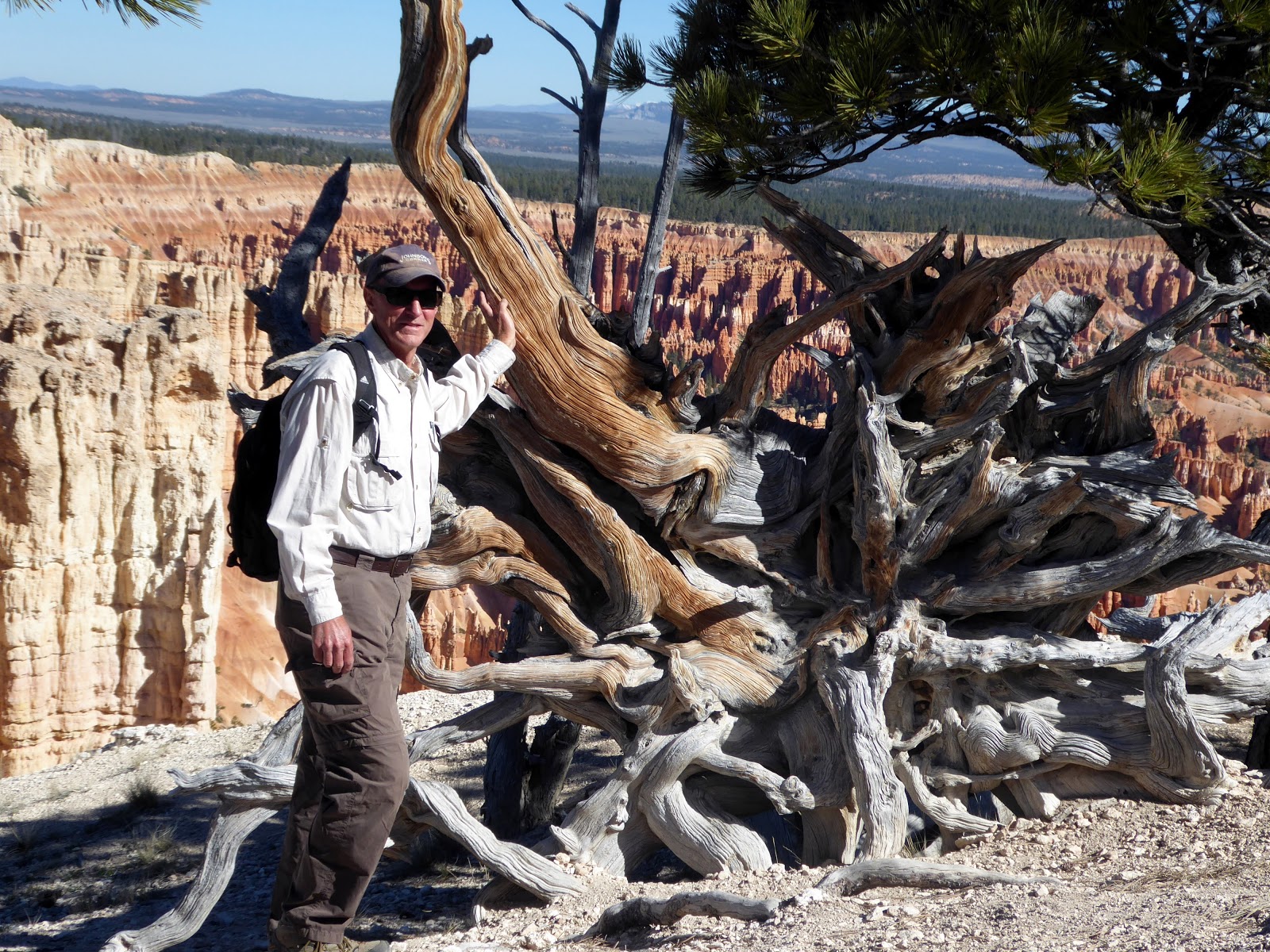
| Interesting roots on fallen tree along rim trail. |
 |
| The sunlight can cause the HooDoos to appear in different colors. |
 |
| Fin formation with HooDoos on top. |
 |
| Many HooDoos look like castles. |
 |
| Connie along the rim trail. |
Once we had finished our hike, we caught the shuttle bus back to the Visitor's Center where we ate the lunch we had packed and waited for our afternoon tour. At 1:30 PM we got on the Rainbow Tour Shuttle Bus and were introduced to our driver and guide, April. April and her husband have a ranch near Bryce Canyon that has been in her husband's family for 5 generations. She drives the tour bus three days a week and does a great job of keeping you interested in facts and myths about the park.
The bus took us to the highest point in the park, Rainbow Point, which is 9,115 feet in elevation. The rock formations in this part of the park are much older than the ones we had seen in the morning. We took a short walk to Yovimpa Point and then to Rainbow Point. April pointed out the different kinds of trees that grow in this section of the park including a bristlebrush pine that can live to be over a thousand years old. The oldest one in Bryce Canyon has been dated to 1,700 years in age while one in northern California is said to be over 5,000 years old. From the top of the park we made stops at the Natural Bridge Overlook and a couple of other overlooks along the road coming down from Rainbow Point. The entire tour was about 3.5 hours and was well worth our time.
 |
| View from Rainbow Point. |
 |
| Some see Bart Simpson while other see a women holding a baby. |
 |
| Natural Bridge formation. There is a photo in the lodge of a cowboy on a horse on top of this. |
|
 |
| Angel Wings? |
At the end of a long day we made the drive back to Glendale (about an hour) and had a quick supper, shower and on to bed.


No comments:
Post a Comment
We would love to hear from you, so please comment.